Landscape Character Assessment
The scheme area is within the boundary of Natural England’s National Character Area Profile 21: Yorkshire Dales, which provides an assessment of the Yorkshire Dales landscape as a whole. This provides a basis from which to get a flavour of the important characteristics of this upland area:
- The landscape is characterised by contrasts, especially between the dales below and the moors above.
- In the dales, the environment is more sheltered and there are intricate patterns of walled fields containing meadow grasses and wildflowers.
- Small villages and farmsteads, built of local stone, are tucked into sheltered corners, often with clumps of trees protecting them from the worst of the elements.
- On the dale sides, the network of walls continues with scattered stone field barns often appearing as distinctive features.
- The steepest slopes are frequently marked by the presence of sparse woodlands or sometimes open rock scree.
- There are large areas of actively managed grouse moorland.
The area boasts nationally and internationally significant heritage assets: dramatic landscapes, a rich diversity of wildlife and habitats, and history and culture through the ages, from prehistory, the beginnings of recorded history, the medieval and post-medieval periods and the modern era.
Geology
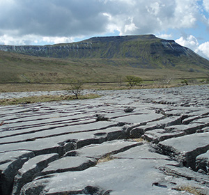
The landscape has a unique character. Much of it results directly from the rocks, the effects of the ice ages and the way people have influenced the land since the ice melted. Millions of years of Earth history have culminated in the landscape we know today. The rocks and fossils tell a story of the evolution of the area from deep oceans, tropical seas, swamps and tropical forests. The most recent times have culminated with the ice ages and erosion to form the present-day landscape.
The area has developed its own distinctive scenery – the karst landscape, produced by the weathering and erosion of limestone resulting in a striking mix of towering cliffs, bare rock, scree slopes, deep gorges, limestone pavements, potholes, sinkholes and cave systems. The area includes some of the best examples of this type of scenery within the Yorkshire Dales National Park and within the UK as a whole.
Biodiversity
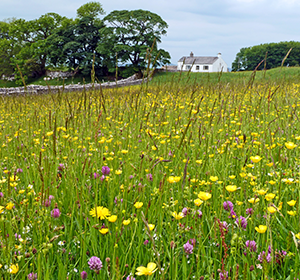
The sweet grasslands of the limestone landscapes, a consequence of woodland clearance beginning in prehistoric times, have been grazed for centuries, resulting in a generally open landscape with little woodland cover. The short springy limestone pastureland, grazed by sheep, supports a great variety of flowering plants. Good examples of this type of grassland can be found at Seato Pastures at Chapel le Dale, where flushes and seepages support species-rich vegetation.
Image Credits: Andy Holden
The historical landscape – the story so far…
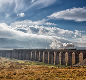
The record of human occupation, exploitation and manipulation of the land extends over 10,000 years, and the range, importance and condition of the historical environment of the scheme area bestows a uniquely rich and precious inheritance. This adds an attractive and important dimension to the area’s landscape character and interest and an irreplaceable record of successive generations’ struggles with their environment. What we see today reflects the impact of many different peoples and cultures, from the first inhabitants following the retreat of glaciers to the migrant workers who built the Settle-Carlisle Railway Line.
Image Credit: Bill Lowis
Buildings and settlements
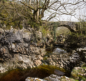
Settlement character is influenced by the underlying geology, which provides a number of sources of rock that are used in building. In Chapel le Dale valley, quarrying of Ingletonian rocks occurs in the Glens, at the lower end of Baxengill Gorge and in Twisleton Glen. The slates have been used in the Ingleton area, over a large part of the south-west dales and in adjacent parts of Lancashire. A large quarry of the same type of slate also occurs as a hole in the floor of the limestone quarry at Horton in Ribblesdale.
Image Credits: Stuart Petch
Industrial development
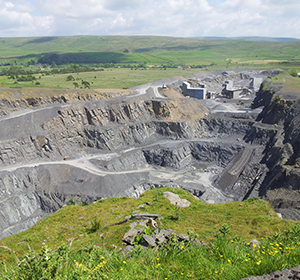
The historical extraction and processing of the area’s stone and minerals have resulted in a rich industrial archaeology and built heritage. Limestone, gritstone and flags have been worked for well over three hundred years for building and roofing materials, to produce aggregates and for lime burning for construction, chemicals and agriculture. These have left a legacy of industrial archaeological remains and dramatic impacts on the landscape.